

A constituency name tells only part of the story; its approximate boundaries show which communities it represents. These Nigeria constituency updates group House of Representatives constituencies by state and pair their names with broad boundary descriptions and examples. The guide makes the state-by-state picture easier to follow while distinguishing approximate descriptions from precise map boundaries.
A constituency name is a useful starting point, but neighbouring communities and local government areas can make the geography less straightforward. This guide sets out constituency names alongside the areas they broadly cover, helping readers identify the relevant seat and understand its reach.
The state groupings and examples provide a practical overview of representation across Nigeria. Use them to orient yourself to the constituency map and its local context. Boundary descriptions are approximate, not detailed surveying information.
Key Takeaways
- Compare House of Representatives seat counts across states to understand how representation is distributed.
- Use constituency names and nearby local government areas to orient yourself to approximate boundaries.
- Learn what to consider when assessing claims that constituency names or boundaries have changed.
- Follow Nigerian and international coverage to keep constituency developments in their wider political context.
Nigeria House of Representatives constituencies by state
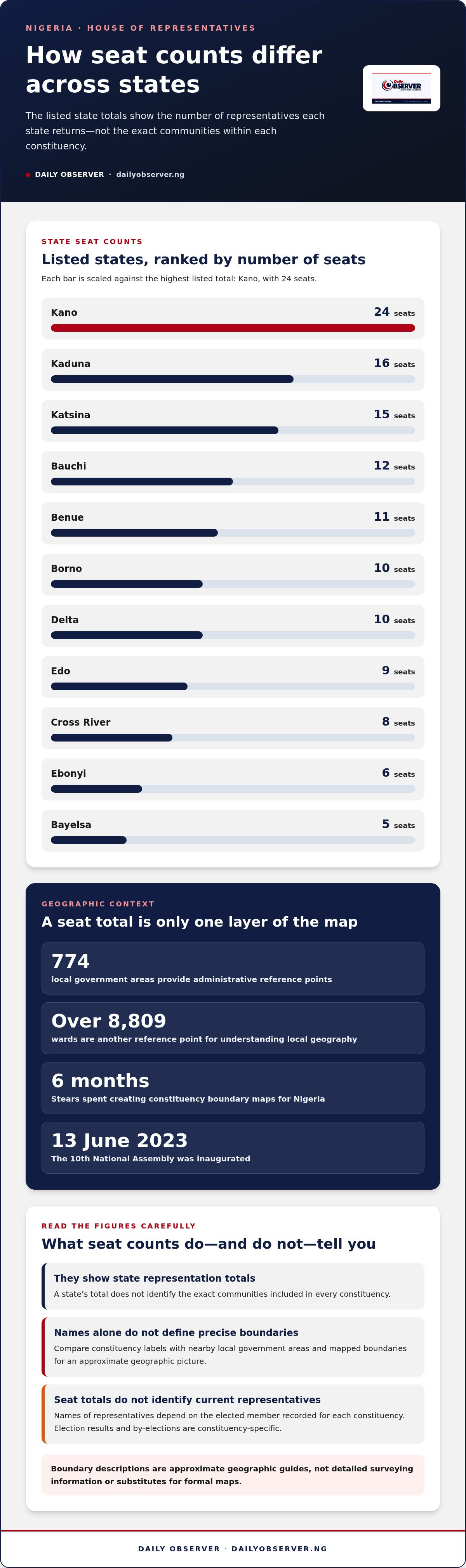
Nigeria’s House of Representatives seats are distributed across states. House seat totals differ among states, so checking constituency information can help clarify the distribution. Bauchi has 12 seats, Bayelsa 5, Benue 11 and Borno 10. Cross River has 8 seats, while Delta has 10. Ebonyi has 6, Edo 9, Kaduna 16, Kano 24 and Katsina 15.
These totals show how many representatives each state returns, not the exact communities within every constituency. Nigeria’s 774 local government areas and over 8,809 wards provide administrative reference points for understanding local geography. A constituency can include several communities or administrative areas, so names alone may not show its full reach.
Mapping House of Representatives constituencies requires matching constituency boundaries with place names and administrative geography. GRID3 Nigeria is described as Nigeria’s open data platform for spatial data. Stears spent 6 months creating constituency boundary maps for Nigeria. These examples show why a map can add context beyond a list of constituency names.
Situation: A reader sees an Abia constituency name but needs to locate its communities. Action: Compare the constituency label with nearby local government areas and mapped boundaries. Result: The reader gets an approximate geographic picture without mistaking the name for a precise border.
Constituency delimitation defines the areas represented by elected members. Each seat is associated with an assigned territory and the communities within it. Read specific boundary descriptions as geographic guides, not substitutes for formal maps.
Project announcements and funding are separate from seat totals. To assess a reported project, identify its constituency, stated funding source and delivery status; no recent project announcement is detailed here. Seat counts show allocations, not the names of current representatives. Those names depend on the elected member recorded for each constituency.
Election results and by-elections are constituency-specific, so a state-wide seat total cannot establish the winner. For current geographic context, compare mapped data with official electoral and legislative records. Nigeria’s 10th National Assembly was inaugurated on 13 June 2023, providing the current Assembly context for following representatives’ work.
Constituency names and state groupings
Names and codes help distinguish geographic groupings, but it is important to identify the electoral category. The examples below are senatorial districts, not House of Representatives constituencies. Their local government area (LGA) lists offer approximate geographic context, not precise boundary maps or a list of federal seats.
- Abia: Abia North, code SD/001/AB, comprises Umunneoichi, Isukwuato, Ohafia, Arochukwu and Bende. Abia Central, SD/002/AB, includes Umuahia North, Umuahia South, Ikwuano, Isiala Ngwa North and Isiala Ngwa South. Abia South, SD/003/AB, includes Aba North, Aba South, Ugwunagbo, Obingwa, Ukwa East, Ukwa West and Osisioma. Situation: a reader encounters three district labels. Action: compare each code with its LGA names. Result: the broad grouping becomes clearer.
- Adamawa: Adamawa North, SD/004/AD, includes Madagali, Maiha, Michika, Mubi North and Mubi South. Adamawa South, SD/005/AD, includes Demsa, Ganye, Guyuk, Jada, Mayo-Belwa, Numan, Shelleng, Toungo and Lamurde. Adamawa Central, SD/006/AD, includes Hong, Fufore, Song, Yola North, Yola South and Gerfi. Situation: district names can be confused. Action: use the code and LGA examples together. Result: each grouping is easier to identify.
- Akwa Ibom: North East, SD/007/AK, includes Etinan, Ibesikpo Asutan, Ibiono Ibom, Itu, Nsit Atai, Nsit Ibom, Nsit Ubium, Uruan and Uyo. North West, SD/008/AK, includes Abak, Essien Udim, Etim Ekpo, Ika, Ikono, Ikot Ekpene, Ini, Obot Akara, Oruk Anam and Ukanafun. South, SD/009/AK, includes Eastern Obolo, Eket, Esit Eket, Ibeno, Ikot Abasi, Mbo, Mkpat Enin, Okobo, Onna, Oron, Udung Uko and Urue Offong/Oruko. Comparing these lists shows how district names divide state geography.
- Anambra: North, SD/010/AN, includes Onitsha North, Onitsha South, Oyi, Ogbaru, Anambra East, Anambra West and Ayamelum. Central, SD/011/AN, includes Awka North, Awka South, Njikoka, Anaocha, Idemili North, Idemili South and Dunukofia. South, SD/012/AN, includes Ihiala, Nnewi North, Nnewi South, Orumba South, Orumba North, Aguata and Ekwusigo.
- Bauchi: South, SD/013/BA, includes Alkaleri, Kirfi, Bauchi, Tafawa Balewa, Bogoro, Dass and Toro. Central, SD/014/BA, includes Ningi, Warji, Darazo, Ganjuwa, Misau and Damban. North is SD/015/BA. These examples show why codes are useful alongside names.
For the wider political context around constituency developments, follow Nigerian constituency reporting.
Have any Nigerian constituency boundaries or names changed recently?
A changed map, revised label and formal boundary change are different claims. The examples available for Bayelsa East, Benue North East and Delta Central identify senatorial districts, not House of Representatives constituencies. Their codes and listed areas describe groupings; on their own, they do not demonstrate a recent alteration. Treating a new map label as proof of a legal change risks confusing presentation with representation.
Situation: Bayelsa East appears as SD/016/BY, with Brass, Nembe and Ogbia. Action: Compare that code and composition against a dated record for the same type of electoral area. Result: You can distinguish a changed description from a changed boundary. A senatorial district code must not be presented as a House constituency identifier.
Benue North East offers another test. Its SD/019/BN grouping includes Katsina-Ala, Konshisha, Kwande, Logo, Ukum, Ushongo and Vandeikya. If a source shows a different spelling or area list, first establish whether it uses the same electoral level and the same record date. Then compare the named places, rather than relying on a headline or map image alone.
Delta Central, SD/028/DT, includes Ethiope East, Ethiope West, Okpe, Sapele, Udu, Ughelli North, Ughelli South and Uvwie. A credible change assessment should identify the earlier and later records, explain the affected places, and distinguish a proposed revision from an implemented one. Without those details, the claim remains difficult to evaluate.
For practical tracking, record the constituency name, electoral category, identifier, boundary description and publication date. Compare like with like: a House constituency with another House constituency, not with a senatorial district. A place-name difference may reflect spelling or data presentation; a boundary change requires evidence that the represented area itself differs. This keeps updates about Abia, Adamawa or any other state grounded in comparable records, rather than assumption.
What are the latest updates for each state constituency in Nigeria?
State-level updates need clear labels. Keep House of Representatives seats distinct from senatorial districts, election results and project reports, as these records describe different aspects of representation. Mixing them can make a boundary description look like a legislative change. For each state, identify the type of update first, then its area and date.
Borno North is a geographic grouping, so check its electoral category before treating it as a constituency. Its listed areas include Abadam, Gubio, Guzamala, Kukawa, Magumeri, Marte, Mobbar, Nganza and Moguno. Situation: a reader sees the district name in a state update. Action: identify the senatorial category and compare its areas. Result: the information is not mistaken for a House constituency list.
Cross River North, SD/025/CR, includes Bekwarra, Obanliku, Obudu, Ogoja, Yala and Biase. Situation: an update mentions one of these local government areas. Action: check whether the report concerns district geography, a representative, an election or a project. Result: the reader can distinguish a location reference from a change to constituency representation.
For each state entry, record the state, constituency name, electoral category, identifier and communities described. Add the publication date and type of development. Record a representative’s legislative activity separately from a boundary description. An election result belongs under electoral information, while a public works announcement belongs under project reporting.
Compare like records across states. For example, assess Borno North alongside another senatorial district, not a House seat. A change in wording alone does not establish a changed boundary; look for a clear comparison of the previous and current areas. This keeps Nigeria constituency updates organised by state and helps readers follow representation without confusing geography, elections and legislative work.
Edo State has 9 House of Representatives seats. Kano State has 24 House of Representatives seats. These counts give readers a state-level reference point when organising updates about House representation, but they should not be treated as senatorial district totals or as evidence of an electoral or boundary change.
When reporting developments, keep the seat count distinct from details about individual constituencies, representatives, elections and projects. This makes it easier to compare updates of the same kind and see whether a report concerns the number of seats or activity within a particular area.
Daily Observer: Nigerian and international news coverage
Daily Observer covers Nigerian and international news for readers following constituency representation and wider political developments. Its reporting and analysis can place a local announcement, legislative activity or election result in a broader national context. Follow its coverage to keep up with developments beyond constituency names and approximate boundaries, and to understand how Nigerian affairs connect with international events.
For ongoing civic reporting, compare the constituency details in this guide with coverage of the relevant political developments. Visit dailyobserver.ng to read Daily Observer’s news coverage.
Keep following the issues that shape representation
Treat Nigeria constituency updates as an ongoing civic record, not a one-off lookup. When a new announcement appears, note whether it concerns a representative’s activity, a local issue, an election matter or an area description. Keeping these categories distinct makes later developments easier to compare and prevents one headline from defining the whole story.
Choose a constituency question to follow next. Record the issue and its location, then look for subsequent public statements or developments. This gives community discussions a clearer reference point and helps distinguish an ongoing matter from a single announcement. Over time, your notes can show how public concerns and political attention evolve.
If a constituency issue prompts a wider question about Nigerian public affairs, contact Daily Observer to continue the conversation. Staying attentive to local developments is a practical way to take part in informed civic discussion.
Frequently Asked Questions
What are the latest updates on Nigeria's federal constituencies?
The latest Nigeria constituency updates covered here concern state groupings and approximate geographic descriptions, not a verified announcement of new House boundary changes. To assess a fresh claim, note its publication date and electoral category, then compare the named areas with an earlier record of the same type. This helps distinguish a revised description from a substantive change affecting representation.
How can voters find their constituency and representative in Nigeria?
Start with the state and local government area where you live, then identify the House of Representatives constituency associated with that location. To find its representative, match the constituency name against election results for the relevant seat, rather than relying on a district name alone. Keep the electoral level consistent: a senatorial district and a federal constituency refer to different forms of representation.
Where can I find official Nigeria constituency updates and current data?
Compare mapped data with official electoral and legislative records for current geographic and representative context. GRID3 Nigeria is described as an open data platform for spatial data.